
Page 59 - GIS for Science, Volume 3 Preview
P. 59
Today, Gorongosa National Park is a spectacular 6,700 km2 preserve located at the southern end of the Great East African Rift Valley. Gorongosa encompasses almost all types of habitat found in southern Africa, with a variety of microclimates and environments created by unique biogeographical features and a range of altitudes. Fed by rivers originating on Mount Gorongosa, the floodplain of Gorongosa National Park supports some of the densest wildlife populations in all of Africa, including charismatic carnivores, herbivores, and 475 bird species. Populations of many species of large mammals such as waterbuck (Kobus ellipsiprymnus), impala (Aepyceros melampus), and sable antelope (Hippotragus niger) have either returned to or exceeded pre-war levels, and other species such as the African bush elephant (Loxodonta africana) and African buffalo (Syncerus caffer) are quickly approaching them. Other species have been successfully reintroduced, such as African wild dogs (Lycaon pictus). Yet there is much still to be learned about many of the park’s lesser- known species that build and support the ecosystems in which these high-profile examples of charismatic megafauna reside.
In March 2013, an expedition led by Dr. Naskrecki set out to conduct a survey of the Nhagutua Gorge (accessible only by helicopter), with a focus on detecting differences in species composition across an elevational gradient in smaller species not detectable by aerial surveys. Equipped with Sherman traps, mist nets, and pitfall traps, Dr. Naskrecki and his team gathered samples of rodents, bats, and dung beetles. The dung beetles alone comprised hundreds of specimens belonging to 12 separate genera, illustrating the astonishing diversity that individual regions can hold.
This single population survey exemplifies the extraordinary amount of coordination and effort to collect species data and the diverse historical contexts that surround each datum. Mapping the planet’s biodiversity is only possible because of the blood, sweat, and tears of the countless thousands of individuals who have dedicated their time in gathering data, observations, and samples in the field, and make that information available to others. You can read more about the E.O. Wilson Biodiversity Laboratory and Gorongosa’s community-based natural resource management efforts in this volume’s online resources at GISforScience.com.
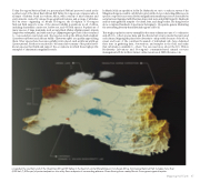
Located at the southern end of the Great East African Rift Valley in the heart of central Mozambique in Southeast Africa, Gorongosa National Park includes more than 4,000 km2 (1,500 sq mi) of protected park on the valley floor and parts of surrounding plateaus. Rivers flowing from nearby Mount Gorongosa irrigate the plain.
Mapping Half-Earth 47
