
Page 19 - GIS for Science, Volume 3 Preview
P. 19
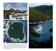
   In addition to the diversity of physical, ecological, and human factors used to classify coastal areas, important geographic and temporal dimensions help frame coastline classification efforts. These four images represent different spatial vantage points for coastal exploration that influence classification scale and granularity: on-shore (top left, Portland Head, Maine), off-shore (right, the Australian research vessel Sprightly), low altitude (facing page, Malibu, California), and high altitude (above, North Sentinel Island, Andaman Islands, India).
Earth’s Coastlines 7
