
Page 188 - GIS for Science, Volume 3 Preview
P. 188
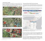
3. Detect objects in imagery
In Tonga, an archipelago in the South Pacific, inventorying each palm tree and building on Kolvai’s landed estate would take a lot of time and require a large workforce. To automate the process of geographic feature extraction for this location on the island of Tongatapu, students train a deep-learning model to identify tree species of interest and houses in the imagery collected by a drone.
The process of building training data begins with circling all the known palm trees in a small sample area.
This procedure is repeated for several areas of a set of images. The same training process is run for buidlings.
An example of detections produced by a student-trained neural network after appproximately one hour of training.
4. Recognize and extract entities from unstructured text
It is a labor-intensive task to read through thousands of documents and extract information useful for further GIS analysis. The EntityRecognizer module in ArcGIS API for Python uses deep learning to learn from just a few hundred labeled text reports.
In this exercise, students create a training set from unstructured police reports, train an EntityRecognizer model, and then apply it to extract geographic features automatically from thousands of similar text documents in seconds.
Entity-recognizing software interface used to extract geocodable addresses, times, dates, names, and other facts from text documents.
The extracted features are then published as an ArcGIS Online feature service and added to a Webmap, ready for further spatial analysis.
The exercises are organized in a progressive disclosure form, taking students first through a simple workflow of training a neural network using ArcGIS Pro user interface tools, and then diving deeper into Python code organized into visually rich, convenient Jupyter Notebooks annotated with detailed technical instructions and recommendations.
This way, students gain an insight into the deep-learning training process: grasp the concepts of overfitting and underfitting, importance of validation-train splits, training data augmentation, optimal learning rate search, etc. The allotted virtual machine time also allows for experimenting with neural network architectures and inviting students to compete with each other for the best metric accuracy.
     176
GIS for Science
