
Page 187 - GIS for Science, Volume 3 Preview
P. 187
DEEP-LEARNING LAB AT UC SAN DIEGO
Given the importance of the deep-learning workflows and availability of cost- efficient GPU offerings by multiple cloud providers, we have successfully offered a set of deep-learning exercises to the data science students at UCSD since 2019. In 2020, we used Amazon EC2 G4 instances equipped with NVIDIA T4 GPUs, which worked well for running these exercises. Specifically, the g4dn.XL instances come with affordable hourly rates, allowing us to stay within a small budget for classes of 40–50 students.
Each student (or pair of students) was given a designated cloud virtual machine with a preconfigured software stack (Microsoft Windows, ArcGIS Pro, ArcGIS API for Python, Doccano), step-by-step PDF instructions for each exercise, initial ArcGIS Pro project files, data, and semicomplete Python notebooks. The student ArcGIS Online accounts (or Portal for ArcGIS accounts) used to sign in to ArcGIS Pro were provisioned with the ArcGIS Image Analyst extension.
Students were asked to complete four exercises during the limited time window of three days. Each exercise required the students to complete the full deep-learning cycle: create and export training data, train a specific deep neural network, validate the resulting model, run the model on unseen data and, finally, write a short essay documenting the student’s observations of the training process, hyperparameter search, and reasoning about further potential improvements of the models.
The exercises cover four scenarios with distinct workflows:
1. Feature classification in world imagery
Forest fires can spread quickly and destroy thousands of acres of land. In California, where many urban areas infringe on forest lands and native habitat, wildfires threaten people’s lives and homes. The 2018 Woosley Fire affected almost 100,000 acres of forest and threatened nearly 50,000 people in Ventura and Los Angeles counties. During a disaster, time is of the essence for response and recovery efforts. Unfortuantely, the lack of real-time data and and need to interpret data manually can cause critical response delays. In this exercise, with the help of deep-learning, students quickly and accurately identify urban structures that have been destroyed by fires and structures that are still safe.
Damaged structures have a distinct digital signature that the neural network learns to recognize through training data.
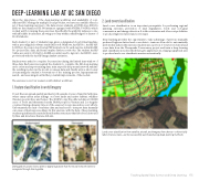
2. Land cover classification
Land cover classification is an important prerequisite for performing regional planning exercises, prevention of land degradation, forest and ecological conservation, and change detection. It is labor-intensive and often cost-prohibitive to produce high-resolution land cover maps.
Deep learning provides the opportunity to take advantage of previous manually produced high-resolution land cover data to train an AI model to automatically perform this task. In this exercise, students use a portion of 1-meter resolution land cover data from the Chesapeake Conservancy project and train a deep-learning pixel classification model, which then gets applied across a large geographical area to produce land cover classification raster automatically.
Land cover classification from satellite, aircraft, and imagery from drones—a historically labor-intensive task—can be successfully automated using deep-learning methods.
Teaching Spatial Data Science and Deep Learning 175
