
Page 180 - GIS for Science, Volume 3 Preview
P. 180
AN EXPLORER’S MINDSET
As young geographers, Soon and Rockey exemplify what it means to have an explorer’s mindset. Cultivating this mindset begins with persistent curiosity, a passion for finding out, and a restless quest for answers. As young people explore the world around them, curiosity becomes the energy that drives their learning. Curiosity is energy. And fueling that curiosity is one of the most effective ways that educators can help their learners develop the attitudes, skills, and knowledge to become architects of change.
Fueling curiosity
Educators in the broadest sense are instrumental in helping young people develop the essential attitudes, skills, and knowledge to:
• lead, seek solutions, and tell stories.
• become informed, curious, and capable individuals committed to making
the world a better place.
• have a sense of responsibility and respect for other people, cultures, and
the natural world.
• make a difference, pursue bold ideas, and persist in the face of challenges.
• observe, document, and engage with the world around them.
• create and foster a global community committed to a sustainable future.
• support diversity, equity, and inclusion in their communities and
respective fields.
An array of tools helps educators to engage learners in asking questions, investigating, collecting data, thinking critically, and developing solutions. This is a striking shift from the older methods of giving students chapters to read and facts to remember. Students take on some of the most perplexing problems of the world and use tools such as National Geographic’s own MapMaker, ArcGIS Online, ArcGIS Survey123, and ArcGIS StoryMaps to design and communicate solutions.
How can communities combat plastic pollution? How can human activities help animal migration? How can we actively save species from extinction? From collecting and visualizing data to studying evidence and forming hypotheses, no learners are too young to start thinking like geographers.
Rockey says she wishes she had access to GIS earlier in her schooling before she was a university student. Just recently, she used GIS to map the spatial distribution of students categorized by educational qualifications around the city of York. She says providing children with earlier access to geographic tools can help them address challenges in their community and inspire them to embark on careers in which they can put their problem-solving skills to use.
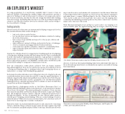
Lindsay Hyneck, a kindergarten teacher at Oak Harbor Elementary School on Whidbey Island in Washington State, created a lesson to foster an explorer’s mindset in her 5-year-old students. “This meant pushing the boundaries of their curiosity, their observational skills, and their knowledge with a hands-on approach,” Hyneck said. She brought her learners outside to map the community around the school through photography. As they documented the area, Hyneck asked questions with the goal of inspiring critical thinking: “Why are certain buildings located in particular places? What civic resources are important to be located near a school? And how does city design lead to healthy communities?”
Back in the classroom, students studied their photos and created a floor-sized map of their community. Using construction paper, paint, and other supplies, they built schools, businesses, and parks and placed them on the map. They discussed how the
map looked from above and whether all communities looked like theirs. With that in mind, Hyneck then led her students in a lesson about other island communities and asked them to compare Whidbey Island to the Isle of Man in the Irish Sea. “They started locally and observed globally,” the teacher said. By mapping their community and examining essential questions, they drew connections to another island on the other side of the world.
While Hyneck’s kindergartners are perhaps not quite ready to use mapping tools such as ArcGIS online, the applied learning they are doing is a first step in that
Oak Harbor Elementary students map their Whidbey Island environs in 3D.
direction. It develops their spatial thinking, helps them understand their place in the world, and empowers them to see themselves as explorer, even without leaving their small island.
Observation notes showing that Whidbey Island, Washington, and Douglas, Isle of Man, aren’t that different after all.
168
GIS for Science
