
Page 155 - GIS for Science, Volume 3 Preview
P. 155
GLOBAL SOUNDSCAPE MODELING
Applying the GIS workflow to global ship-tracking databases such as the Spire Global AIS dataset, along with global weather, bathymetry, and bottom composition, makes it possible to model the entire global soundscape in near-real time. This workflow application can help marine biologists understand the communication and sensing capabilities of marine mammals or help law enforcement and military personnel understand the performance of acoustic monitoring networks. Modeling the global soundscape presents four primary challenges:
1. Computational expense: An estimated 200,000 commercial ships operate in the ocean; capturing small-scale variability in noise from wind and waves requires global soundscape models
at approximately 1 km resolution. And powerful computers
must run efficient algorithms to model these sources in near-real time.
2. Input database management: Acoustic models require accurate information about seawater and bottom properties. As a rule, these environmental inputs should be known with more than one- half wavelength resolution. For 150 Hz acoustic simulations, this means 5 m voxels. These datasets also must be kept up to date. As with any computer simulation, effective management of input environmental data is key.
3. Process optimization: The mathematics involved in the parabolic equation-based acoustic simulations used for soundscape modeling have existed for decades, and sources such as Spire Global make obtaining global ship-tracking datasets fairly straightforward. The challenge becomes setting up a computational architecture
to grid and discretize environmental data inputs, manage and filter source information, schedule computational load online and on physical computer servers, and then effectively store simulation results.
4. Data analysis: Once the acoustic simulations have
been completed, further analysis is needed to understand
the soundscape. Source levels must be applied to each ship,
and based on international databases and historical empirical measurements. Then the data must be made available to organizations that need it through web-API or a data marketplace
such as Esri’s ArcGIS Marketplace or ArcGIS Online. The data must be
in a format accessible to organizations that need it and communicated in a clear and accessible way.
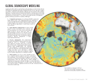
Plot of global soundscape for 50 Hz at 100-meter receiver depth simulated using global ship-tracking data and global wind data.
The Science of Ocean Acoustics 143
