
Page 121 - GIS for Science, Volume 3 Preview
P. 121
For paddle sports and seafood restaurants, simple heat maps were generated, but no quantitative values were applied.
Results
Across the combined CROP countries, tourism expenditure directly linked to on- reef activities is estimated at $118 million annually. This expenditure can also be expressed in terms of visitor numbers, with 83,000 overnight visitors and 60,000 cruise visitors choosing these islands for their on-reef activities. Natural values of the beaches in the CROP countries are estimated to be generating some $318 million of tourism expenditure annually with 143,000 overnight visitors and 565,000 cruise visitors attracted specifically to the pristine, natural aspects of the region’s beaches.
The on-reef values explored here are considerably higher than those projected from the 2017 global assessment, which estimated a total value of $73 million per year. This increase is largely driven by increases in tourism arrivals and expenditure between these two studies.
Conclusion
This is the first time that these components of nature-based tourism associated with coral reefs have been so extensively mapped and analyzed at these resolutions. The results are of considerable use for understanding the value of coral reefs and coastal ecosystems at local scales applicable to management. They should support a broad range of users from the public to industry to government to better plan and manage the tourism industry and other sectors whose actions could either support or jeopardize these values. The maps are also valuable for future planning. In this context, looking at places within countries and between countries might provide models for future natural resource management, for example, in restoring natural values as a way to expand natural benefits to new locations.
User-generated content from large crowdsourced datasets such as Flickr and Tripadvisor serves as a very powerful tool for understanding relatively fine-scale patterns in tourism. Concerns have been raised about accuracy bias, and the reality that any public-sourced datasets have a high ratio of errors. Nevertheless, it is the high volume of data that makes these datasets valuable, enabling us to smooth over the occasional errors. Other platforms, notably social media platforms, would represent another rich source of data. However, such platforms do not allow large- scale data extraction and cannot at present be used for data mining in this way.
One key element of this work is the high degree of local engagement that enabled us to enhance the data from these more international sources, and proof, corroborate, or correct the final models and output maps. While AI/ML methodologies are an improvement on previous studies, the benefit from extensive regional engagement cannot be overstated. Local data collectors obtained country-level data from government agencies, scientists, and other sources. These datasets serve to ground- truth and enhance data derived from global sources, including AI/ML output. Data were further verified through stakeholder engagement activities, bringing together experts who have deep familiarity with data inputs, and the locations being characterized. This level of participation is not feasible for modeling activities at the global or even regional scale, but it allowed the team to refine our methodologies. These data products are directly responsive to the needs of people who could ideally use this information to support their work. This process also validates the AI/ML output that can then be used in CROP work related to marine spatial planning.
Given the impact of COVID-19 on tourism in the Caribbean and the expected changes in demands from a recovering tourism sector, it is highly likely that future tourism will depend even more on natural values and lower-density locations. Because sites of high natural value will likely show an increasing proportional relevance for the recovering sector, the need for conservation in these areas is more important than ever.
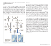
The detailed crowdsource data capture and analysis workflow.
AI for Geospatial Analysiss 109
