
Page 123 - GIS for Science, Volume 3 Preview
P. 123
OceanMind chose the Mascarene Islands IMMA as one of its focus areas. The three islands represent one of the most important breeding and feeding habitats for sperm whales in the southwestern Indian Ocean. The islands also are habitat for calving, nursing, and mating humpback whales and for three dolphin species. The area has high vessel transit activities, creating a higher probability of ship strikes. While some data indicate the presence of marine mammals, the region is still understudied, which was another reason for the focus. With the support of the World Wildlife Fund and Globice (Groupe Local d’OBservations et d’Identification des CEtacés), OceanMind identified risk areas where ship strikes and bycatch by fishing vessels were more likely to occur.
Methodology
1. Data: Mammal tracking data, vessel and satellite data (from photo images to radar), automated tracking signals, and even ship lights can determine a vessel’s movement behavior. The Mascarene Islands IMMA is a data-poor environment for marine mammal occurrences, so the work focused on what evidence the limited data can provide. The Mascarene Islands IMMA was limited to data from a handful of studies and the global assessment of marine mammals by the Ocean Biodiversity Information System (OBIS), which presented numerous gaps compared to other regions such as the North Pacific, North Atlantic, and Southern Oceans, where extensive studies on marine mammal movements have been undertaken. Data on marine mammal movements were derived from visual and acoustic surveys and from a limited number of satellite tracking tags.
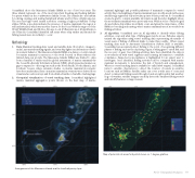
2. Geospatial visualization of vessel tracking data: OceanMind highlighted marine mammal aggregation points (shown on the heat map of marine
mammal sightings) and possible pathways of mammals compared to vessel activity. Reported sightings of marine mammals were mostly anecdotal because satellite tags registered only a few data points of their positions. So OceanMind created a grid to compile available information and therefore highlight where the most marine mammals were previously seen. While not free of bias, the grid showed where ship strikes most likely occur, and given the importance of this IMMA to breeding and nursing, where marine mammals are at most risk from fishing activities.
3. AI algorithm: OceanMind uses an AI algorithm to identify where fishing activities occur and what type of fishing gear may be in use. Fisheries experts trained the algorithm using vessel tracking data representing thousands of vessel-years of fishing of different kinds to make this possible. Where vessel tracking data such as Automatic Identification System (AIS) is available, OceanMind can accurately detect fishing to the point of recognizing different phases of fishing, such as the deploying of gear, soaking gear to catch fish, and the recovery of gear. Once fishing activities have been identified, the data is cross-referenced with vessel registries and licensing information to establish compliance. Suspected noncompliance is highlighted for an expert user to investigate. Once identified, fishing activities can be compared with marine mammal movements to determine the risk of bycatch and entanglement. Where no vessel tracking data is available (so-called dark targets), OceanMind turns to satellite observations to detect the location of vessels in sensitive locations such as IMMAs. Satellite radar can cover a wide area of ocean and detect commercial fishing vessels through clouds, at night, and in bad weather. In good weather, satellite imagery can help detect the smallest fishing vessels and identify features on larger vessels.
Arrangement of the Mascarene Islands and the local bathymetry layer.
Map of potential risk areas for bycatch shown on .1 degree gridlines.
AI for Geospatial Analysiss 111
