
Page 119 - GIS for Science, Volume 3 Preview
P. 119
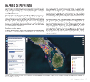
MAPPING OCEAN WEALTH
The Caribbean is more dependent on the travel and tourism sector than any other region worldwide, accounting for more than 10% of the gross domestic product, and 15.2% of jobs in the region. This sector is almost entirely focused on coastal areas, notably through beach-based activities, cruise tourism, and in-water activities including sailing and diving.
With support from the Global Environment Facility (GEF), the Organisation of Eastern Caribbean States (OECS), and in partnership with the World Bank, The Nature Conservancy (TNC) used an approach called Mapping Ocean Wealth to develop ecosystem service models and maps at the scale of the eastern Caribbean. This work in Dominica, Grenada, Saint Lucia, St. Kitts and Nevis, and St. Vincent and the Grenadines supports the Caribbean Regional Oceanscape Project (CROP), an effort to foster this region’s blue economy and promote greater consideration of the region’s ecosystem functions and services through ocean policy development and coastal and marine spatial planning.
Mapping ecosystem services
Coral reefs that encircle most islands draw tourists, either directly through scuba and snorkeling or indirectly through beach-related activities and access to seafood.
Even so, the connections between these ecosystems and the personal, direct benefits they generate across these societies can be difficult to quantify. Without such information, opportunities to enrich society through improved management, reduced user or use conflict, and restoration, or enhancement of ecosystem functions may be lost. Mapping Ocean Wealth quantifies and maps the linkages between vulnerable natural habitats such as coral reefs and tourism revenues associated with these habitats, asserting that protecting these habitats is a win-win for economies, livlihoods, and ecosystems alike.
One persistent challenge when mapping the spatial footprint of tourism activities is the lack of authoritative, spatially explicit data describing what tourists do and where. Previous studies addressed this gap by using crowdsourced data to evaluate patterns of tourism associated with a specific activity. In 2017, the Mapping Ocean Wealth team, including partners at the World Resources Institute, the Natural Capital Project, University of Cambridge, and University of Edinburgh, published a study and global map describing worldwide patterns of coral reef tourism and related expenditures using keyword searches of tagged photos uploaded to the photo-sharing website Flickr. Using the coordinate embedded in photo metadata, the researchers plotted locations of scuba and snorkeling activities which, combined with other data inputs, allowed them to map activity and tourism values to the locations of coral reefs.
 This web application presents the results of the AI analysis of crowdsourced imagery collected in the Caribbean as a way to catalog ecosystem services provided by coral reefs and their surrounding environments.
AI for Geospatial Analysiss 107
