
Page 118 - GIS for Science, Volume 3 Preview
P. 118
106
GIS for Science
GIS ON THE NEURAL NETWORK
Facing unprecedented challenges, the world needs our help to mitigate climate change, ensure abundant water supplies, feed a growing population, and confront the catastrophic loss of biodiversity. Finding solutions can be daunting when it comes to understanding the natural world because we face an information drought.
Facing these challenges, the emergence of artificial intelligence (AI) has accelerated the path to a better, more sustainable future. AI allows us to automatically collect and process huge amounts of data that would otherwise require vast amounts of human capital. Recent machine learning advancements allow these systems to match and even surpass human accuracy for tasks such as image classification, population mapping, and habitat monitoring. The intersection of AI and geographic information systems (GIS) presents an opportunity to solve some of the world’s most pressing environmental challenges.
Increasing numbers of sensors, satellites, and drones provide more available data and meaningful analysis and at a greater rate than previously possible. The growing capability of cloud computing, machine learning algorithms, and deep neural networks all support GIS. which in turn becomes more useful when it capitalizes on powerful cloud computing capabilities, ever-improving machine learning algorithms, and deep neural networks.
Microsoft AI for Earth empowers organizations to innovate at the intersection of environmental science and data and computer science. The program, according to Microsoft, focuses its AI and research technology on four areas of environmental sustainability: agriculture, water, biodiversity, and climate change. Recognizing the importance of applying AI approaches at cloud scale to geospatial data, the AI for Earth grants program was launched in 2017. By partnering with Esri from the beginning, grantees received access to Microsoft Azure and Esri ArcGIS software. Esri’s data analytics and mapping technologies paired with Microsoft’s cloud and AI solutions deliver crucial insights to conservationists worldwide. To date, the program has supported more than 700 grantees working in more than 100 countries.
This chapter will present two projects that have used geospatial AI approaches to work on important issues in conserving marine biodiversity—one from the Caribbean and the other featuring the remote Mascarene Islands east of Madagascar.
The importance of the ocean to global environmental health cannot be overstated. According to the United Nations Educational, Scientific and Cultural Organization (UNESCO), the ocean is the source of more than half of the oxygen we breathe. It profoundly affects climate and weather and absorbs nearly a third of the carbon dioxide emitted into the atmosphere because of human activities. The ocean has socioeconomic impacts on many nations, with the livelihoods of many impacted by the ocean’s health. Because the ocean is so vast, pairing AI with remote sensing can help us better understand and monitor the breadth and depth of marine ecosystems.
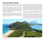
Saint Kitts and Nevis were among the first islands in the Caribbean to be colonized by Europeans. Today, the islands’ rich but fragile marine ecosystem benefits the region economically, in part through tourism.
