
Page 62 - GIS for Science, Volume 3 Preview
P. 62
TAXONOMIC REPRESENTATION AND DATA GAPS
To date, the Half-Earth Project Map includes global patterns of richness and rarity for all known species of amphibians, birds, mammals, reptiles, cacti, and conifers. These groups are displayed because of their comprehensive representation, i.e., every known species is accounted for. The Half-Earth Project is engaged in expanding the taxonomic coverage of the map to other groups such as ants, bees, butterflies, dragonflies, vascular plants, marine fishes, and crustaceans.
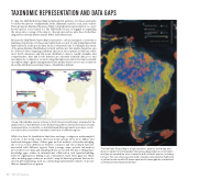
Because the Half-Earth Project Map is intended to inform and guide conservation planning, its patterns of richness and rarity must account for any spatial biases that may be present in the species data. At the continental scale, for example, the extent of the genus Bombus (bumblebees) is fairly well known, but sizable disparities can be observed when mapping individual species at finer spatial resolutions: while most North American and European distribution data is readily available and comprehensive, Asia and South America are currently relatively data poor and incomplete by comparison. As such, using the higher-resolution but taxonomically incomplete map to guide management decisions may lead to erroneous conclusions about the distribution and importance of bumblebee habitat.
A map of bumblebee species richness in North America and Europe, compared to the global extent of bumblebees (inset). Biodiversity patterns inferred from taxonomically unrepresentative, incomplete, or spatially biased data may lead to erroneous conclu- sions about the conservation importance and value of different regions.
While it is clear for bumblebees that there are large, contiguous, undersampled portions of the world, many other taxonomic groups show more diffuse and scattered data gaps. Many of these gaps are best understood by acknowledging the socioeconomic differences between countries and the political histories associated with different regions. Data coverage maps provide information about where more data and sampling efforts are needed. The key to filling these knowledge gaps resides in international collaboration and capacity-building between organizations linking local communities. Until these gaps are filled, other modeling approaches are needed to map biodiversity patterns that can be used in global planning, such as constructing representative subsets of species that are sampled across genera.
The Half-Earth Project Map is a high-resolution, dynamic world map and decision-support tool that guides where place-based species conservation activities are needed the most to save the bulk of Earth’s species, including humans. This view shows taxonomically complete rarity patterns (high rarity in yellow) for the world’s 276 known species of hummingbirds, overlaid with currently protected areas (red areas).
50
GIS for Science
