
Page 56 - GIS for Science, Volume 3 Preview
P. 56
THE NEED FOR SPATIAL BIODIVERSITY DATA
W e are drowning in information, while starving for wisdom. The world henceforth will be run by synthesizers, people able to put together
the right information at the right time, think critically about it, and make important choices wisely.”
—E.O. Wilson
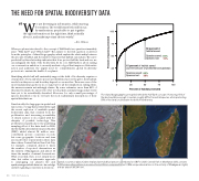
When people are introduced to the concept of Half-Earth, two questions invariably arise: “Why half?” and “Which half?” The answer to the first question is derived from the principles of island biogeography, which explain the relationship between the amount of habitat and the number of species that habitat can sustain. The curve predicted by this relationship indicates that if we protect half the land and sea, we can safeguard the bulk of the biodiversity. At its core, Half-Earth is about raising our conservation ambition to an easily understood goal that inspires collaborative action and addresses the urgent need for comprehensive, global biodiversity protection to sustain the health of our planet.
Identifying which half will sustainably support the bulk of biodiversity requires a clear picture of how and where species are distributed across the globe, their habitat needs, how they move, and how they depend on one another. These are some of the most fundamental questions in ecology, but for all the simplicity in stating them, the answers remain astonishingly elusive. By some estimates, more than 85% of the planet’s eukaryotic species (in other words, plants, animals, fungi, and protists) have yet to be scientifically described. Moreover, for only a small percentage of species described so far do we have the most rudimentary descriptions of their spatial distributions.
100 75 50 25 0
●
●
50 percent of habitat saved.
Species saved: 84% Species lost: 16%
15 percent of habitat saved
(current amount of protected land globally).
Species saved: 62% Species lost: 38%
Paradoxically, the large gaps in spatial and taxonomic coverage have persisted through the recent explosion of available spatial biodiversity data that resulted from the proliferation and increasing accessibility of citizen science tools coupled with the ubiquity of portable technology. This proliferation is partly due to the underlying sampling effort of the data itself: in 2020, the Global Biodiversity Information Facility (GBIF) added almost 28 million user- contributed species occurrence records, but some geographic locations and taxa are much better represented in these data than others. Central Park in New York City, for example, contained almost 3 times the number of reported observations as the entirety of Madagascar, and almost 10 times the number of animal observations. What is needed, then, is not simply more data, but rather a systematic approach to cataloguing our planet’s life and synthesizing available data into knowledge useful for guiding conservation decisions.
Spatial occurrence data of plant (red) and animal (blue) species contributed to GBIF in 2020. Central Park in Manhattan (left) contains 9,104 unique observations in an area of only 3.4 km2, compared to just 3,846 unique observations in the entirety of Madagascar (right), with an area of 587,041 km2.
0 25 50 75 100
Percent of habitat protected
The island biogeographic principles behind the Half-Earth concept. Protecting 15% of the land could be enough to sustain roughly 60% of terrestrial species, while protecting 50% of the land could sustain the bulk of biodiversity.
44
GIS for Science
“
Percent of species protected
