
Page 23 - GIS for Science, Volume 3 Preview
P. 23
METHODOLOGY
Initial plans and evolution of the segmentation approach
Our paper describing the development of the global shoreline vector1 also presented a preliminary vision for how we would conceptualize and map ECUs, wherein we committed to develop global ECUs as an objective, quantitative segmentation of the global coastal zone into environmentally distinct and ecologically meaningful units. That initial vision included a notion to bound the global coastal zone as a set of nearshore coastal waters extending out to the 30-m bathymetric contour line, offshore coastal waters extending from the 30-m bathymetric contour out to the continental shelf edge, and coastal land areas extending from the coastline landward to the edge of the continental plain or to mountain systems. We then anticipated attributing the area inside this coastal zone with relevant ecological setting variables in a wall-to-wall (completely spatially tessellated) fashion. We held a workshop to elicit expert opinion on the specifics of bounding the coastal zone on land and in the water and to generate the list of variables that would adequately describe the coastal settings. (Workshop resources are linked at GISforScience.com.)
Initial attempts to delineate a global polygonal coastal zone area within which we would characterize coastal ecosystems proved challenging, mainly with respect to bounding the land-side area. While the much narrower shore-zone concept is understood as that portion of the profile subject to wave action, the larger coastal zone is an onshore and offshore area influenced by proximity to the coast, with ill- defined limits on both sides.22 Deciding how far out in the water and how far in on the land we should extend the coastal zone proved problematic due to the difficulty in knowing the nature and magnitude of coastal influence at progressively longer distances seaward or inland.
Ultimately, we abandoned the attempt to delineate a standardized polygonal global coastal zone within which we would map ecological settings in a wall-to- wall fashion as impractical and overly ambitious. We do see the value of such an effort and encourage future attempts to do so. For our purposes, however, we decided that adopting a coastline segmentation approach would provide a simpler and more practical opportunity to characterize coastal environments while still retaining the ability to include considerations of land-side and water-side ecological settings. Coastal segmentation is focused on partitioning the coastline into a set of relatively homogenous reference units based on physical and ecological (and sometimes socioeconomic) properties and using these coastline units for resource management or research programs. Coastline segmentation approaches seek to identify similar coastal systems that may exhibit similar responses to disturbances or management interventions.23
Our work to identify the coastal segment units (CSUs) and ecological coastal units (ECUs) represents a global partitioning of the coastline into 1-km segments, an attribution of those segments with ecological setting data followed by a classification, and a spatial statistical analysis of the segment properties. The work proceeded in four steps:
Step 1 - Development of the global shoreline vector (GSV)
To develop a strong global characterization of coastal ecosystems, we first needed to produce a new, high-resolution global shoreline vector (GSV) as the spatial and linework foundation for the effort. We produced that vector shoreline through a semiautomated interpretation of year 2014 annual composite Landsat images for every image on the planet that contained a coastline. That work was published in a special GEO Blue Planet (a GEO oceans initiative) issue of the Journal of Operational Oceanography.1 It contains the details about how the GSV was extracted from
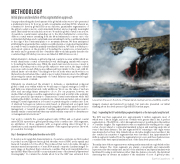
Lava enters the sea on the shore of Hawaii island, creating new low-erodibility coastline.
imagery, cleaned, and rendered topological. Our team also presented our initial thinking about the development of global ECUs in that paper.
Step 2 - Segmenting the GSV and identifying segment midpoints as the basic spatial analytical unit
The GSV was then segmented into approximately 4 million segments, most of which were 1 km in length, and none of which were greater than 1 km. A perfect segmentation of the GSV into only 1-km segments was not possible given the realities of coastline lengths. The segmentation was accomplished by starting at the origin vertex of every island or continental mainland polygon and inserting endpoints at every 1-km linear distance. The last segment before returning to the origin vertex was always shorter than 1 km. Islands whose shoreline lengths were less than 1 km also resulted in a number of segments that were less than 1 km. Approximately 4 million segments resulted from the segmentation process, and these features were considered the basic spatial analytical unit of the data development effort.
The midpoints of these segments were subsequently extracted into a global shoreline points dataset. The 1-km segments are always conceptually and numerically represented by their midpoints, and all of the attribution and spatial analysis was facilitated by using point features rather than line features. As such, the statistical clustering was in essence an analysis of the similarity of a set of global points,
Earth’s Coastlines 11
