
Page 162 - GIS for Science, Volume 3 Preview
P. 162
150
GIS for Science
VALUE OF GIS
Researchers increasingly understand the importance of soundscape to marine mammals, humans, and planet Earth. As we have seen, the global soundscape can affect everything from a whale’s ability to find a mate to a submarine’s ability to stay hidden beneath the ocean’s surface. GIS technology is one of the big reasons that research has progressed in the study and understanding of soundscape. Researchers use GIS to process, curate, and manage the 4D datasets required to do high-quality acoustic modeling. GIS allows researchers to quickly analyze the results of an acoustic simulation, such as those generated in the examples in this chapter, and turn it into something meaningful. Spatial analysis can help us answer questions about marine mammal stress and ecology and tell us where to deploy acoustic sensors to detect a vessel fishing illegally in a closed area. The scientific community needs tools that make this type of analysis available to everybody who needs it, from marine biologists and conservationists to law enforcement officials and military officers.
Applied Ocean Sciences (AOS), with its partners Spire Global and Esri, continues looking for innovative ways to make soundscape data and acoustic analysis tools available for wider use. We have created the capability to combine Spire’s real- time and forecasted ship-tracking and weather data with AOS’s acoustic models, delivered through the ArcGIS Pro platform for the scientific community.
5
2
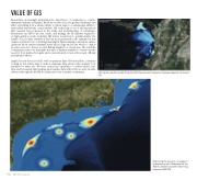
GIS can be used to model the potential future acoustic impacts of a proposed port on marine life.
Plot of received level (how loud it will be) of a humpback whale call north of the island of Oahu in the Hawaiian Islands (5). To determine where that whale might be detected by other whales, researchers must determine the ambient noise levels (soundscape).
Measuring the acoustic coverage of hydrophones off of Maryland for the Atlantic Deep Ecosystem Observing Network (ADEON).
4
