
Page 126 - GIS for Science, Volume 3 Preview
P. 126
TERRESTRIAL SPOTLIGHTS
Trust for Public Land
Interest has grown in recent years to understand the value of city parks and open spaces, not just as social and recreational areas, but also as sources of economic and health benefits. The American Planning Association (APA) convened its City Parks Forum in the early 2000s to create a nationwide conversation about the role and importance of city parks. Subsequent research found that in addition to recreational, social, and aesthetic benefits, parks and open spaces provide health and economic benefits.
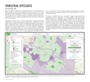
With this knowledge, the Trust for Public Land (TPL) has long worked with urban communities to create parks and protect public land to benefit everyone. Its ParkScore Index evaluates the effectiveness of parks in the largest US cities, and TPL plans to expand that work to many more communities nationwide. This index is designed to help local communities improve their park systems and identify where new parks are needed most. TPL built on the concept of ParkScore by launching ParkServe, an interactive platform to track urban park access nationwide. The central concept of ParkServe (and ParkScore) is to determine and map the number of city residents who have access to a park, playground, or publicly accessible
protected area within a 10-minute walk. By mapping the existing parks, population density, and other demographics, ParkServe also reveals what areas of a city are underserved by parks.
TPL aims to eventually scale up to nationwide coverage, serving nearly 14,000 municipalities and more than 80% of the US population. Such national-level analysis requires more computing power and infrastructure than TPL’s existing in-house systems and would make it difficult for TPL to perform other mission- critical work. With an AI for Earth grant, TPL performs cloud computing through the Microsoft Azure platform. TPL also uses ArcGIS Pro housed in a Microsoft Azure Geo AI data science virtual machine (Geo-DSVM). The Azure Geo-DSVM was specifically designed in collaboration with Esri to support geospatial analytics capabilities through interoperation with ArcGIS Pro. The resulting analysis will help TPL explore trends and impacts around parks and communities, such as how much the parks are being used or how well each park provides health and environmental benefits.
114
GIS for Science
ParkServe, an interactive platform to track urban park access nationwide. The central concept is to map how many people living in cities have access to a park, playground, or publicly accessible protected area within a 10-minute walk.
