
Page 127 - GIS for Science, Volume 3 Preview
P. 127
Optimizing streamflow prediction
Students at Brigham Young University’s (BYU) Hydroinformatics Lab saw the potential to optimize streamflow prediction using cloud computing and GIS modeling systems. This strategy allows researchers to use a web-based platform, eliminating the need for expensive high-performance computer hardware. It also ensures evergreen data and reduces the need for local storage capacity.
Using Esri’s ArcGIS platform, students produced streamflow forecasting, flood mapping, and data sharing tools that stakeholders can access. With advanced modeling, mapping, and visualization, water resource managers can make more informed decisions. The platform creates a Himalayan Streamflow Forecaster app, which produces a 15-day view of streamflow and flood risk. This capability allows affected regions to better prepare for flooding and become more resilient after floods and other disasters.
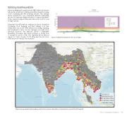
View of streamflow forecast for the next 15 days.
Map showing watershed boundaries and locations where streamflow is forecasted to exceed flood threshold.
AI for Geospatial Analysiss 115
