
Page 83 - GIS for Science, Volume 3 Preview
P. 83
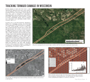
 TRACKING TORNADO DAMAGE IN WISCONSIN
Forests change in many way from year to year. Typically, this change involves year-to-year variation in forest dynamics, such as tree recruitment, growth, and death. However, some changes occur in relatively short time, such as during forest disturbances including wildfire, insects and disease, and tornadoes. These kinds of disturbances, while naturally occurring in forests, substantially impact forest ecosystems and communities, more specifically, wildlife, timber, recreation, and so on.
Tornadoes are a local and destructive disturbance, felling trees, damaging property, and threatening lives in many parts of the United States, For example, a tornado swept through a portion of Wisconsin that is characterized by a diverse mix of forests and agricultural lands. The tornado converted live trees to snags and down wood over the course of minutes, Given the relatively small footprint of many tornadoes (10s to 1000s of hectares), few if any FIA plots may overlap tornado tracks, requiring a mapping approach quantifying the magnitude of tornado impacts, such as mapping the changes in live tree biomass or carbon (map 2). Even if some plots overlap tornado tracks, it is likely that too few plots will be available for traditional estimation (mean and variance), requiring small area estimation approaches that use plot data and maps. Small area estimation can allow land managers, property owners, and policy makers to visualize the consequences of a disturbance, and its uncertainty, to help them plan for the future. (map 3).
2
Carbon Stock Change Increase
Decrease
1
Post-tornado, the damage scar (characterized by a decrease in carbon stock) is shown
as dark patches.
0 1 2 4 6 8Kilometers
From Plots to Pixels 71
Wisconsin landscape shown in per-tornado condition (with the future path of destruction track shown).
Earthstar Geographics
3
Live Tree Biomass 0-1 (tons/acre) 1-2 (tons/acre) 2-3 (tons/acre) 3-4 (tons/acre) 4-5 (tons/acre) 5-6 (tons/acre)
>6 (tons/acre)
0.4 0.3 0.2 0.1
0
1
2
4
6
Maxar
8Kilometers
Maxar
8Kilometers
4
Mean estimates of post-tornado live tree biomass at 250-ha scales. (inset) Vari- ance,ameasureofestimateprecision,canitselfvarywiththemeanbiomassin km forests, highlighting the degree of uncertainty in estimates.
0 1 2
6
Estimated Variance
23456
Mean Live Tree Biomass (tMoaxanr s/acre)
0 2 4 8 12 16
